
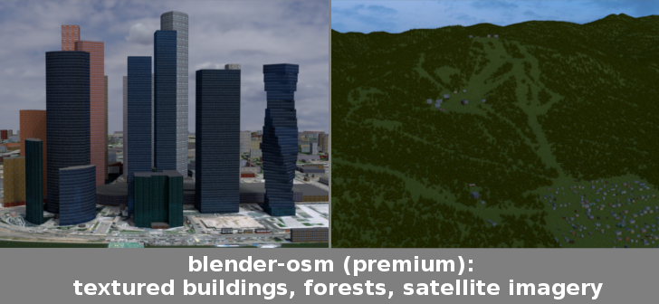
Blender-OSM: textured buildings, forests, satellite imagery
vvoovv writes:
Time to announce the premium version of the blender-osm addon. In addition to the features of the base version (3D volumes for OpenStreetMap buildings and terrain), the premium one provides:
- Import of buildings from OpenStreetMap with default materials, tileable building textures and UV-mapping applied
- Default materials and textures to mimic lit windows for a late evening setting
- Import of forests and single trees as 3D objects
- Options to use custom tileable building textures (e.g. from textures.com)
- Satellite imagery and web maps projected on a terrain
you haven’t included a video tutorial,so I’m not able to figure out if this addon can help me. for this reason,I can’t buy it. BUT I keep it in consideration in the future,when you will make a video that explain better what i can do with it. thanks.
You can find the full documentation here: https://github.com/vvoovv/blender-osm/wiki/Premium-Version . It’s not a video, but you should be able to see if this fits your needs.
thanks. anyway,reading a lot of technical argumentation does not help me to have a global idea about the product and it does not help me to understand what it means pratically what he says here :
Important notice: the addon does not provide real textures for each imported building!
Important notice: materials with textures aren’t exported to external formats at the moment since they are designed for Cycles rendering engine!
I mean,I need to understand how is the quality of the product and how much it is decreased ’cause his limitations.
https://www.youtube.com/watch?v=i4ySFm4ey9U&t=2078s – a quick search shows this video showing the Blender add on and what it can do i.e. download a selected area on a map in 3D.
premium addon must be free, according to the federal law they have no rights to sell this product, they must provide it for free…satellite data and high quality images is something that belongs to the general public. expect some kinds of feud in court for this…good luck
This isn’t true. The law only specifies a resolution limit, which actually may be changing anyway. But either way, the charge is obviously for the very legit time, effort and code of the addon. The addon has a place for you to use an ArcGIS or Mapbox token for satellite imagery. So, even if there were an issue, ESRI, Mapbox & Google would probably have been sued and shut down by the government a while ago. The only functionality for satellite imagery that I see in this addon is literally passing something you buy from someone else into the addon.