
Add-on: Import SRTM Terrain Data
Import 3D Topographical Earth data into Blender with this add-on by vvoovv.
About SRTM:
The Shuttle Radar Topography Mission (SRTM) obtained elevation data on a near-global scale to generate the most complete high-resolution digital topographic database of Earth. SRTM consisted of a specially modified radar system that flew onboard the Space Shuttle Endeavour during an 11-day mission in February of 2000.
vvoovv writes:
The add-on imports terrain data from the SRTM project. The SRTM data cover the majority of the earth mainland and are freely distributed. Details how to download the terrain data and how to use the addon can be found on the link below.
When i try to import i got an error saying that the .hgt file is missing, even whn is already there.
Here is a capture of the bug.
https://dl.dropboxusercontent.com/u/56354395/error_hgt_001.avi
it seems like the file im using is corrupted. I tried a different latitude and it worked. You got to change end clipping at the camera a lot as you said in your web, mine went to 1million.
I normally set far clipping distance to 10 thousand.
I’ll check the files you mentioned in your message
It’s my bug. n37w001 to n37w009 are in the western hemisphere. So far I tested the addon only with files from the eastern hemisphere. I hope to fix the bug soon.
The bug is fixed. Please download the new version of the addon, reinstall it and try it again.
@acassani:disqus
I tested the addon with the file N37W001.hgt. It worked for me. Also, consider using the “Use manually set extent” option to import a smaller area.
Is working now.
Thanks a lot
Could you provide a screenshot with your import setting?
here you got a capture. Hope it helps
https://dl.dropboxusercontent.com/u/56354395/bug_002.avi
Here is the explanation.
The latitude and longitude in the name of a .hgt file refer to the longitude and latitude of the lower-left (southwest) corner of the file area. Each .hgt file covers one degree by one degree in latitude and longitude.
You entered: latitude: [0…1], longitute:[0…1]. This area lies it the Atlatic ocean to the west from Africa. The addon reports which SRTM files it requires for the entered area. You will need to download those files. However, there is no land in the ocean, and no SRTM files for oceans and seas.
Try to enter the following area which is contained in N37W004.hgt:
min lat: 37.1, max lat:37.3
min lon: -3.3, max lon -3.1
To find coordinates of the desired area use http://www.openstreetmap.org/export
Press “Manually select a different area” on the left (it may be written on your language)
Adjust the the box over the map
Use coordinates on the grey rectangle on the left.
I would recommend that your area spans not more than several kilometers or dozens kilometers
Thank you very much sir, now i understand it.
Thanks for your time and effort.
Really nice addon
Hi Vladimir,
Thank you for your dedicated work on these areas and specially for Blender3D now. I went through some of your wonderful work on your GitHub pages, the plug-ins/add-ons that you have got to offer.
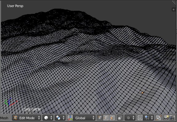
I am yet to test an import for OpenStreetMap but I did check for SRTM (.hgt) file. It worked without much issues except it produces some artifacts in the form of “holes” of certain surface area and it gets flattened at the very bottom.
I am providing a screen-shot to make it more clearer, hope that helps.
I suspect the problem is due to the following fact. SRTM data may contain occassional voids. The addon replaces any void with zero. I can do nothing here.
Still, please write which .hgt file you tried to import?
The example that I have used above is N47E009.hgt
And oh I understand if it’s the problem with the void RTM data itself. In that case, I may delete those bottom-flatten vertices and use Grid Fill tool (intregrated well within set of numerous mesh operations).
As I see, you have a well documented wiki, you may add this as an extra info that other users might find useful. Or you can as well include those set of macros within the addon itself, that might be accessible to adjust the parameters (via Toolself or HotKey F6) upon adding the mesh data object onto the Scene and as per required.
However, I know it’s just an approximation method but if anyone comes with a much better technique to resolve this, I would be glad to implement that as well.
I tried N47E009.hgt and confirrm that the file contains voids.
By the way, it’s possible to use SRTM and OSM addons together. OSM and SRTM data will be placed correctly with respect to each other.
Great!
So, for that to work seamlessly will I have to make my Blender scene Georeferenced before importing both OSM and SRTM data?
No. If the active scene is not georeferenced, georeferencing will be assigned by the addon automatically.
Here is the excerpt from the documentation.
If the active scene does not have custom properties “latitude” and “longitude” or if “Ignore existing georeferencing” checkbox is checked, custom properties “latitude” and “longitude” are set for the active scene. They correspond to the center of the imported terrain area.
If the active scene does have custom properties “latitude” and “longitude” and “Ignore existing georeferencing” checkbox is unchecked, the custom properties “latitude” and “longitude” are used as the center for the import. In other words, the newly imported terrain area will be placed correctly with respect to previously imported terrain areas.
I have one more question, if I may. :D
Is it possible to get more finer details for a close-up point-of-view or the only option we have is to sculpt it through.
And is there a way to map the OpenStreetMap data on top of a hilly terrain as shown here. http://bit.ly/1jFU0Ha
The addon imports everything contained in a .hgt file. Unfortunately, no finer details from the addon.
I’d like to place roads, buildings, lakes, etc on the terrain. Probably I’ll implement that in a separate addon.
Now I need map texture from same coordinate to make perfect rendering
Really excellent plugin Vladimir! Thanks a lot, or shall I say спасибо. Great for architectural previs.
came across this plugin while searching for a way to use srtm data in unreal engine. downloaded plugin, setup in blender, followed the instructions on how to put in the specific area I wanted to work with, blender sits there, and ultimately from what I can tell, ends up doing nothing. I’m attempting to import tile N35W083 from http://dwtkns.com/srtm30m/, I’ve tried 35.00 min 36.00 max lat and I’ve tried both 83.00 to 84.00 and -83.00 to -84.00 for longitude. In the process of trying wider and smaller areas, files have been added to my folder directory. Example, N34W083.SRTMGL1.hgt has N34W083.hgt as well now since my attempts to bring them into blender. It has been a very long time since I’ve used blender, so I know I must be missing something!!
Same problem, installation of module is perfect, but notihing is visible after import.